


Drainage & Flood
Protection Planning
Tremé Urban Flooding Investigation
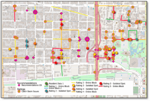
Tremé faces repeated flooding due to outdated grey infrastructure, insufficient storage capacity, and limited block-level infrastructure condition data to inform actionable improvements. Recent flooding events, worsened by runoff from I-10 and Armstrong Park and conveyance issues have taken a toll on both residents’ property and well-being.
In response to this chronic flooding and resident concerns, Water Wise Gulf South, The Greater Tremé Consortium (GTC) and Healthy Community Services (HCS) engaged GreenPoint Engineering to lead a neighborhood-scale investigation into the causes of flooding in Tremé.
This project sought to:
- Identify root causes of localized flooding through field investigation and system analysis.
- Engage residents and local stakeholders to ground the technical work in lived experience.
- Assess and map drainage deficiencies, such as clogged or undersized pipes, pump limitations, and illegal or obstructive construction.
- Develop an actionable strategy combining grey infrastructure rehabilitation with green infrastructure enhancements.
Based on the full neighborhood assessment, GreenPoint has prepared recommendations for each block, compiled from field observations, resident feedback, and historical and existing drainage data. The recommendations fall into several key categories:
Catch Basin and Manhole Investigation: Manhole and surface inlet inspections should be the first step for locations with suspected clogging.
CCTV Survey and Drain Line Cleaning Plan: As much of the system appears to be backed up with years of organic debris and trash, a targeted CCTV and cleaning effort is strongly recommended for blocks identified as clogged or severely impacted by flooding.
Drainage and Road Infrastructure Improvements: New drainage infrastructure should be considered for blocks that currently lack any catch basins or where surface grading does not allow runoff to reach inlets. Where evidence of concrete in lines or failed infrastructure exists, repair and possible line replacement will be necessary. Any confirmed lateral or trunk line damage should be used as an opportunity to evaluate the value of upsizing.
Pump Station and Canal System Review: As blockages are cleared and more flow is conveyed downstream, the impact on DPS 3 and the Orleans Canal should be closely monitored.
Best Management Practices: While larger fixes require city action, everyday flooding can be reduced through simple maintenance and behavior changes by both residents and public agencies and staff.
Mid-Barataria Sediment Diversion – Interior Drainage
GreenPoint provided hydraulic modeling, engineering and construction support to the AECOM design team for the Mid‐Barataria Sediment DiversionGreenPoint led the interior drainage improvements associated with the project, including hydraulic modeling, calibration, design and technical operation and maintenance recommendations of the inverted siphons, among the largest in the world, that will convey up to 1,000-cfs of stormwater as well as necessary modifications to the existing 1,000-cfs USACE-designed drainage pumping station at the drainage basin outfall.
Design Considerations
To support the initial benefit-cost analysis, GreenPoint’s effort began with the evaluation of two selected methods, inverted siphon and pumping, by which drainage can be maintained once the diversion channel is constructed. With the State’s selection of the inverted siphon approach, GreenPoint proceeded with the conceptual design of the inverted siphon banks and the reconfiguration of the interior drainage features to convey the entirety of stormwater flow to the siphon. The accepted design consists of six 96-inch siphon tubes extending below the planned 800-foot wide diversion channel to connect the drainage basin bisected by the project.
Modeling and Calibration
Using current topographic surveys and LiDAR data of the area’s drainage features, GreenPoint created the existing conditions model to reflect the current conditions and features of the existing drainage area in HEC-RAS and HEC-HMS. GreenPoint then calibrated the existing conditions model by monitoring channel depth and pump operation at the Wilkinson Pump Station after several significant rainfall events by gathering pump operation logs and water level data. The calibrated model formed the basis for the development of future conditions models.
Hydraulic Design
The evaluation of hydraulic conditions and the subsequent design of hydraulic features to maintain interior drainage upon construction of the diversion channel were based on a level of service consistent with a 10-year, 24-hour storm event. Drawing on GreenPoint’s inverted siphon conceptual designs dictated by the future conditions models, the design team evaluated the inverted siphon alternative with respect to life-cycle costs anticipated over the 50-year useful life of the system.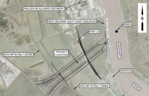
Seventh Ward Urban Flooding Investigation
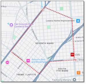
GreenPoint Engineering partnered with WaterWise Gulf South and Healthy Community Services to conduct a comprehensive drainage assessment in the historically disadvantaged and flood-prone Seventh Ward of New Orleans. The project focused on identifying chronic flooding patterns, evaluating existing infrastructure conditions, engaging community collaboration, and establishing a data-driven foundation for future drainage improvements.
Community Engagement
Community engagement was central to the project. GreenPoint conducted listening sessions and educational workshops, distributed questionnaires, and incorporated photo documentation from residents to supplement technical data and fill critical gaps in City records. Historical 311 complaint data and stormwater modeling reports were used to validate and correlate findings.
GIS Geodatabase
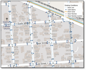
The scope included collecting and analyzing a broad set of data sources: GIS drainage maps, Sewerage and Water Board of New Orleans (SWBNO) and Department of Public Works (DPW) as-builts, topographic surveys, hydrologic/hydraulic models, and rainfall data from 2015–2025. A GIS geodatabase was developed to integrate infrastructure data, community-reported flooding locations, and severity ratings, supporting spatial analysis and visualization of high-priority problem areas.
Key Deliverables
Key deliverables included a prioritized list of flooding hotspots, a Seventh Ward Data Collection Log, GIS mapping layers of infrastructure and concern areas, cleaning and CCTV protocol, and preliminary improvement recommendations. This assessment will inform future drainage investments by aligning technical analysis with neighborhood-driven insight, advancing equitable and resilient stormwater planning for the community.